Key Takeaways
- 3D scanning in construction uses laser or LiDAR technology to capture millions of data points, creating accurate as-built digital twins of buildings, sites, and infrastructure.
- Typical accuracy ranges from 2–4 mm, which dramatically reduces rework, RFIs, and change orders on real construction projects.
- The technology supports the full project lifecycle: existing conditions surveys, design coordination (Scan-to-BIM), construction verification, and facilities management.
- By 2026, 3D laser scanning and LiDAR have become standard tools on complex commercial, industrial, and infrastructure projects worldwide.
- This article covers concrete examples across stadiums, plants, hotels, treatment facilities, and historic buildings, plus practical guidance on costs and implementation.
Introduction to 3D Scanning in Construction
This guide is intended for construction professionals, project managers, and facility owners interested in leveraging 3D scanning technology. 3D scanning for construction is transforming the industry by improving accuracy, reducing costs, and enabling better project outcomes. What started as a niche application for industrial plants in the 1990s has evolved into a mainstream construction workflow. Back then, only the most complex piping and equipment documentation justified the expense. Today, plummeting hardware costs, portable LiDAR integration, and seamless BIM software compatibility have made 3D scanning for construction accessible to projects of nearly any scale.
3D scanning in construction uses laser technology to create precise digital 3D models of physical spaces (Fact: 1). The scanner captures data in a point cloud format, which consists of millions of data points in a 3D coordinate system (Fact: 3, 2). In construction contexts, 3D scanning—also called reality capture—uses scanners and LiDAR-equipped devices to record point cloud data representing actual site conditions. These laser scans generate dense datasets comprising millions of precise measurements that feed directly into CAD and BIM platforms for coordination.
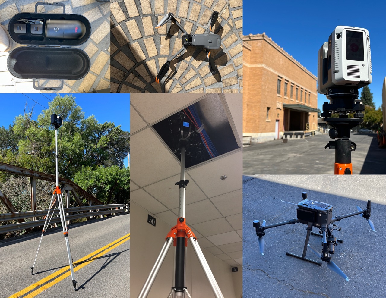
The main hardware types include:
- Terrestrial laser scanners: Tripod-mounted units delivering the densest, most accurate point clouds for interiors
- Mobile scanners: Devices like NavVis M6 using SLAM technology for rapid traversal, capturing millions of data points across large spaces
- Drone-based LiDAR/photogrammetry: Aerial capture for exteriors, roofs, and expansive sites
- Handheld/phone-based LiDAR: Quick spot checks and smaller documentation tasks
Processed scans yield deliverables including registered point clouds, 3D BIM models at various levels of development, 2D CAD plans, textured mesh models, and immersive fly-throughs—all used by architects, engineers, and contractors.
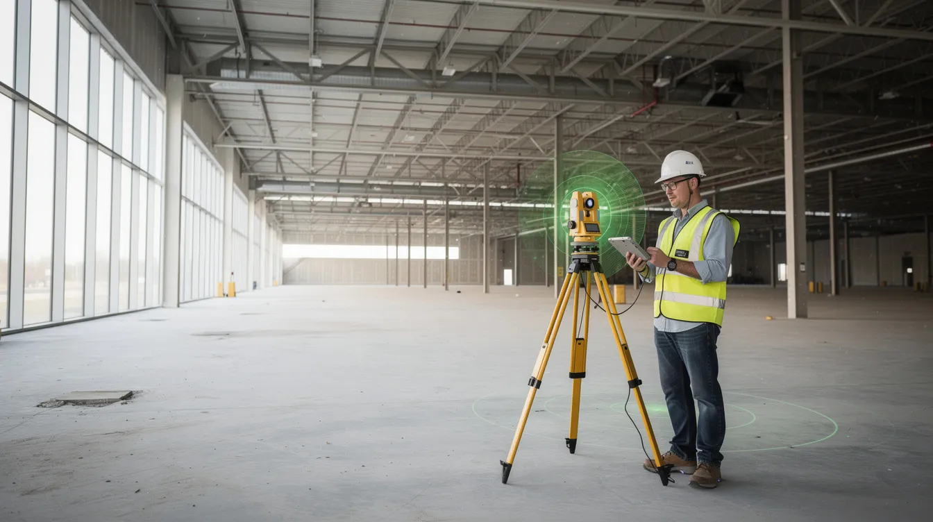
How 3D Laser Scanning Works on Construction Projects
The scanning workflow follows a structured process:
- Planning scan locations for optimal line-of-sight coverage.
- Capturing overlapping scans from multiple positions.
- Registering point clouds into a unified model.
- Exporting into formats like Revit, AutoCAD, or Navisworks.
Here’s how the technology creates exact measurements:
- A terrestrial scanner emits laser pulses up to millions of times per second.
- Each pulse measures reflection time to calculate distance with millimeter accuracy.
- The scanner records X, Y, Z coordinates along with color and reflectance data.
- This process generates dense point clouds capturing the precise geometry of an existing structure.
On a typical project—say, a 200,000 sq ft office building—field work involves setting up hundreds of scan positions over a few days. Skilled operators use targets or cloud-to-cloud registration to align all captures into one coordinated model.
Modern workflows often combine technologies:
- Tripod scanners for interior detail
- Drones for roof and façade coverage
- Mobile devices for rapid area sweeps
All data registers into a single unified model. Current-generation scanners and software allow on-site preview of point clouds, so construction teams can verify coverage before leaving the site.
Core Benefits of 3D Scanning for Construction Teams
Owners, general contractors, and trades now expect scanning on complex work because of measurable ROI. The benefits of 3D laser scanning for buildings span speed, accuracy, collaboration, and safety.
Speed of Data Capture
Speed of data capture stands out immediately. Mobile scanners can capture 100,000–150,000 sq ft per day versus 25,000 sq ft for static methods—roughly 10x faster. A 400,000+ sq ft manufacturing facility that might take weeks to measure manually can be scanned in days.
Improved Accuracy
Improved accuracy at 2–4 mm reduces costly surprises. Point cloud comparisons reveal deviations in piping, rebar, or structural steel before concrete pours, when changes are still affordable. One project detected misaligned steel through scan data, preventing remedial work that would have delayed the schedule.
Reduced Rework and Clashes
Reduced rework and clashes translate directly to the bottom line. Verified 3D as-built documentation replaces outdated drawings, minimizing RFIs and change orders. Retrofit projects particularly benefit, where traditional surveys often lead to errors in the field.
Stronger Collaboration
Stronger collaboration emerges from shared digital twins. Remote teams can navigate panoramic views, markup issues, and measure precisely without repeated site visits. Cloud platforms enable communication across locations, keeping architects, engineers, and contractors aligned.
Better Safety
Better safety comes from noncontact scanning. Laser scans can document bridges, unstable structures, or active process areas without putting personnel at risk.
Typical Construction Use Cases for 3D Scanning
3D scanning now supports everything from pre-design surveys to installation verification and facility handover.
Existing Conditions Surveys
Existing conditions surveys capture full interiors and exteriors of older buildings before renovation. High-density point clouds document irregular geometry, undocumented structural changes, and conditions that old drawings miss entirely. This process establishes an accurate baseline for any project touching an existing structure.
Scan-to-BIM
Scan-to-BIM transforms point clouds into LOD 200–300 Revit models, supporting precision 3D laser scanning and digital documentation across project types. Design teams use these for clash detection in Navisworks, coordination meetings, and fabrication detailing. Semi-automated algorithms now recognize common geometries like pipes, walls, and steel members, accelerating the modeling process.
Construction Verification
Construction verification involves periodic scans of slabs, steel, MEP systems, and façades to compare as-built versus as-designed conditions, often using 3D laser scanning for building inspection and analysis. Teams can verify rebar and piping positions before subsequent trades mobilize, catching deviations while corrections remain practical.
Prefabrication Support
Prefabrication support leverages accurate models for off-site fabrication of clash-free components.
Facilities Management
Facilities management uses persistent digital twins for maintenance planning and building operations over the long term.
Industrial and Infrastructure Applications
Industrial and infrastructure applications—processing plants, water treatment facilities, airports, rail stations—find scanning particularly valuable. Industrial 3D scanning for manufacturing and facility management addresses dense equipment, safety constraints, and operational continuity requirements that make noncontact documentation critical.
Real-World 3D Scanning Examples in Construction
The following examples demonstrate the breadth of applications across project types and scales.
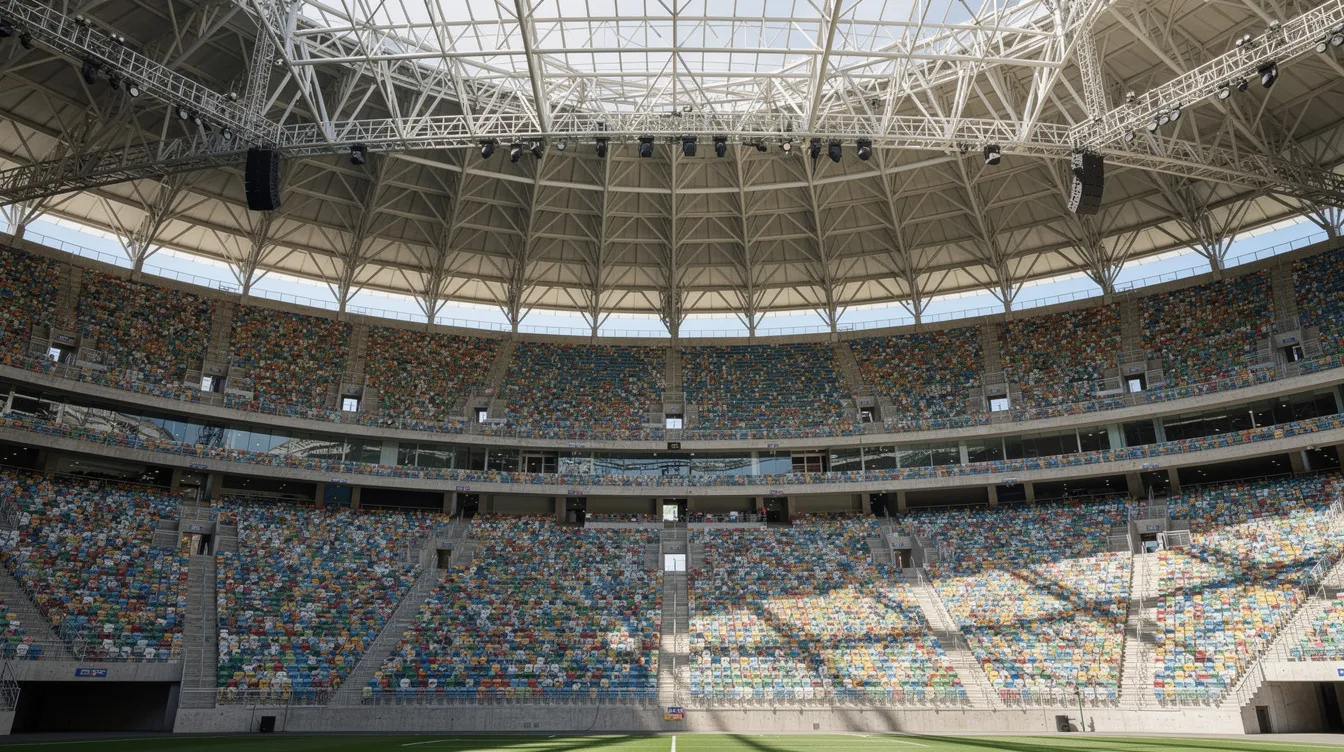
Stadiums and Arenas
Scanning a modern professional stadium captures bowl geometry, roof structures, seating, concourses, MEP systems, and scoreboard assemblies. These projects typically require thousands of scan positions, with drone mapping providing roof and façade coverage.
The resulting 3D data supports both renovation work—steel coordination, MEP upgrades, wayfinding systems—and digital experiences like VR tours and operational digital twins, as well as projection-mapped art installations on historic architecture. Accurate models help with capacity expansions, premium seating redesigns, and technology retrofits such as large-format LED boards or acoustic treatments. Millimeter precision prevents installation mismatches on components ordered months before arrival.
Manufacturing and Processing Facilities
A 400,000–450,000 sq ft multi-level manufacturing plant demands comprehensive documentation of structural frames, mezzanines, and dense process piping, often combining terrestrial scanning with LiDAR and photogrammetry for building inspection. Such projects require thousands of individual scans over 1–2 weeks, later registered into a single coordinated point cloud.
The data converts into LOD 300 BIM models used for retrofit design, line upgrades, or equipment relocation. Millimeter-accurate models reduce shutdown time by enabling more prefabrication and clash-free installations during limited outage windows. One facility cut weeks from design by working from scan data rather than outdated drawings.
Hotels, Offices, and Commercial Buildings
Multi-story hotel scans support renovations, façade updates, MEP replacements, and brand conversions. Teams capture guest rooms, corridors, lobbies, meeting spaces, and back-of-house areas, creating a comprehensive digital twin.
Scanning eliminates repeated site visits and tape measurements. For office tenant fit-outs, scans identify column locations, beam heights, and variable slab elevations not evident in old drawings. This approach proves especially valuable on downtown or occupied buildings where access is limited and downtime must be minimized.
Water and Wastewater Treatment Plants
A typical water or wastewater facility project involves scanning dozens of structures across 50–60+ acres for full documentation. Digesters, clarifiers, and pipe galleries benefit from millimeter-precision models, since misalignment can disrupt process flows or create safety hazards.
3D scanning supports both capital upgrades and ongoing maintenance by providing accurate baseline geometry. Scanning often happens while the plant remains operational, so noncontact methods and minimal personnel presence improve safety and compliance.
Historic and Specialty Structures
A 15,000–20,000 sq ft historic church with no reliable as-builts requires high-resolution scans to capture intricate stonework, stained glass, and timber framing, making historic preservation 3D scanning and documentation essential. Outputs include LOD 200 Revit models suitable for structural analysis, accessibility upgrades, and heritage-compliant renovations.
Museums and terminals scanned during off-hours—early morning or overnight—can be completed in just a few hours, avoiding visitor disruption. These scans support future exhibitions, wayfinding redesigns, and security improvements, similar to case studies where technology supports complex historic preservation spaces.
Integrating 3D Scanning with BIM and Digital Construction
3D scanning delivers maximum value when tied directly into BIM workflows rather than treated as standalone survey data.
Scan-to-BIM converts point clouds into architectural, structural, and MEP models at defined levels of development (LOD 100–350). AI-assisted recognition of common geometries speeds this process considerably.
Integrating point clouds with Revit, Civil 3D, and Navisworks enables clash detection between proposed designs and existing conditions before construction starts. Teams identify conflicts early, when design changes cost far less than field modifications.
Cloud-based collaboration allows architects, engineers, GCs, and fabricators across different locations to review the same dataset. This shared access improves communication and reduces coordination errors.
Digital twins evolve through regularly updated scans combined with IoT data, supporting predictive maintenance and long-term asset management. Facilities teams can plan interventions based on verified geometry rather than assumptions.
Challenges, Costs, and How to Get Started
While 3D scanning offers major advantages, it requires planning, skilled operators, and investment—especially for firms new to reality capture.
Key challenges include:
- Need for experienced operators familiar with registration and field workflow
- Site and schedule access coordination on active construction sites
- Managing large data volumes (gigabytes per project)
- Budget for hardware, software, and training
Professional-grade terrestrial scanners cost $20,000–$100,000 USD as of 2026, with additional software licenses and storage expenses. Many teams start by partnering with specialist providers rather than purchasing equipment.
A simple three-step path:
- Identify a pilot project: Start with a manageable area (around 10,000 sq ft) to test workflows.
- Choose between outsourcing vs. in-house: Base this on project volume and internal capabilities.
- Define clear deliverables: Specify whether you need point clouds only or full Scan-to-BIM models.
Practical advice: perform a small trial first, test workflows with design consultants, and establish data standards (naming conventions, coordinate systems, file formats) before scaling up.
FAQ
What level of accuracy can 3D scanning achieve on construction projects?
Modern terrestrial 3D laser scanners commonly achieve 2–4 mm accuracy at typical construction ranges (10–100 meters), with some high-end units offering finer precision under controlled conditions. Overall project accuracy also depends on survey control, registration methods, and operator skill. Clear tolerances and QA procedures remain critical for reliable results.
How long does it take to scan a building or site?
A small commercial space (10,000–20,000 sq ft) can often be scanned in a few hours. Large facilities spanning hundreds of thousands of square feet or tens of acres may take several days to two weeks on site. Total schedule also includes office time for registration and modeling, which adds days or weeks depending on required detail.
Do I need to buy my own 3D scanner to use this technology?
Many firms begin by partnering with specialized scanning services rather than purchasing equipment, especially for occasional or complex projects. Buying a scanner makes more sense once a company has steady demand, trained staff, and defined workflows with design and construction partners.
Can 3D scanning be done on active construction sites?
Scanning is routinely performed on active sites but requires coordination around access, safety, and line-of-sight—often working during off-hours or between trade activities. Laser scanning is noncontact and generally safe when used according to manufacturer guidelines, though operators must comply with all project safety rules.
What file formats do architects and engineers usually request from scans?
Common deliverables include point cloud formats (E57, RCP/RCS, LAS/LAZ), 3D BIM models (Revit RVT, IFC), and 2D CAD drawings (DWG, DXF) derived from scan data. Agree on software platforms and formats with design teams before scanning so deliverables fit directly into existing workflows.
